
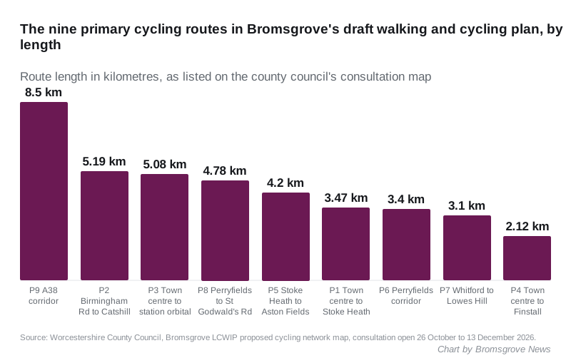
The county's draft plan maps 18 cycling and 12 walking routes across Bromsgrove, from an 8.5km A38 corridor to a station orbital. Comments close 13 December.
Worcestershire County Council has published the first map of where it wants Bromsgrove’s main walking and cycling routes to run, and is asking residents whether it has picked the right streets. Comments close at midnight on Sunday 13 December 2026.
The draft network has 18 cycling routes and 12 walking and wheeling routes. Nine of the cycling routes are marked “primary”, the corridors the council sees as the most important for future investment. The longest is an 8.5km A38 corridor from Worcester Road to the Lydiate Ash roundabout at M5 junction 4.
The engagement opened this week. The plan is a Local Cycling and Walking Infrastructure Plan, or LCWIP. The Walk Wheel Cycle Trust is drawing it up for the county council.
What the plan is, and what it is not
An LCWIP is a list of routes, not a list of schemes with money attached. The council says so plainly: the plans “do not come with direct funding”. Their job is to put the county in a stronger position to bid when government active travel money comes up.
According to the council’s project page and FAQs:
- the routes on the map are indicative, showing corridors rather than exact alignments
- the final Bromsgrove LCWIP report is due in spring 2027
- it will set out a prioritised programme of schemes for the next 10 to 15 years
- every scheme that comes out of it would need its own detailed design and consultation with residents
So nothing on this map will be built because it is on the map. But a street that is left off it is much less likely to get money later.
The primary cycling routes
These are the nine primary routes on the council’s cycling network map, with the length and the main roads each one uses, as the map describes them.
| Route | From and to | Length | Main roads |
|---|---|---|---|
| P1 | Town centre to Stoke Heath | 3.47km | Market Street, St John Street, Worcester Road, Rock Hill, Hanbury Road |
| P2 | Birmingham Road to Catshill | 5.19km | Birmingham Road, Stourbridge Road, Gibb Lane, Barley Mow Lane, Meadow Road |
| P3 | Town centre to the station, as a loop | 5.08km | Worcester Road, Old Station Road, New Road, Aston Fields Recreation Ground, Stoke Road, Garrington Road, Charford Road |
| P4 | Town centre to Finstall | 2.12km | The Strand, Stratford Road, Oakalls roundabout, Regents Park Road, railway underpass to Heydon Road |
| P5 | Stoke Heath to Aston Fields | 4.2km | Wheatridge Road, Newton Road, New Road, Rigby Lane, path beside the railway to Mikado Road |
| P6 | Perryfields corridor | 3.4km | Fox Lane, Whitford Road, Perryfields Road |
| P7 | Whitford to Lowes Hill | 3.1km | Deansway, Millfield Road, Spadesbourne Walk, Sanders Park, Kidderminster Road, Crabtree Lane, Broad Street |
| P8 | Perryfields to St Godwald’s Road | 4.78km | Crabtree Lane, Broad Street, Recreation Road, The Strand, Chapel Walk, A38, Rigby Lane, Finstall Road |
| P9 | A38 corridor | 8.5km | the A38 from Worcester Road to Lydiate Ash |
The nine secondary cycling routes link into those. They include quietways through Sidemoor, Finstall, Charford and Lowes Hill, a Sugar Brook orbital past Avoncroft Museum to Stoke Pound, and an 8.62km Northeast Village Loop from Lickey End through Blackwell to Catshill. A Lydiate Ash orbital runs from Catshill to Upper Marlbrook.
Added up, the route lengths on the cycling map come to about 71km.
The walking and wheeling routes
The walking and wheeling map is shorter and centred on the town. “Wheeling” means people using wheelchairs, mobility scooters or pushchairs. The town centre is marked as a Core Walking Zone, where the council wants to remove barriers to short trips on foot.
Eight primary walking routes run out from it to:
- Perryfields, via Recreation Road and Crabtree Lane
- Finstall First School, via Chapel Walk and the A38 footbridge to Carnforth Road
- Lowes Hill, via Stourbridge Road
- Charford, via Worcester Road, Old Station Road and the path beside Bromsgrove School
- Hill Top, via Spadesbourne Walk
- the railway station, from Bromsgrove School via Aston Fields Recreation Ground
- the A38 junction, along Birmingham Road
- Lickey End, from Lowes Hill via public footpaths
Four shorter secondary routes cover College Walk, St John’s Walk by the church, New Road to the Ryland Centre, and a route past the Princess of Wales Hospital. The walking routes add up to about 16km.
The difficult parts the council admits to
The FAQs are candid about a few things.
- Narrow roads. The council says “some corridors in Bromsgrove have limited highway width”, which can make fully separated cycle lanes hard to fit.
- Perryfields Road will move. The road’s line changes with the new spine road for the Perryfields housing development, and the plan will follow it.
- The A38 works. The routes are meant to build on the walking and cycling paths delivered by the A38 Bromsgrove Route Enhancement Programme, which is still under way. Our latest on that is the minister’s June 2027 date for Oakalls.
- Villages are mostly outside it. The study area is the Bromsgrove urban area. Alvechurch, Barnt Green, Hagley, Rubery and Wythall are not covered. The council says future plans will look beyond the towns, “subject to funding”.
The kinds of improvement it lists as possible include wider footways, new or signalised crossings, kerb-protected cycle lanes, raised tables and 20mph limits, especially near schools.
What it means for you
If you walk, cycle or push a buggy around Bromsgrove, this is the stage where a comment can still change which streets are on the list.
- Look at your own street and your regular journeys on the two maps. Each route has a written description.
- Tell the council what is missing. It asks specifically whether the most important routes have been picked, and where a route is unsuitable.
- Fill in the online survey by midnight on Sunday 13 December. You do not need to cycle to answer: the council wants drivers and bus users too.
- No internet? Staff at Bromsgrove Library will help you complete it. Paper and other formats are available from LCWIPs@worcestershire.gov.uk.
The council says it will not reply to individual comments. A public engagement report will be published with the final plan next spring.
Road closures and live works across the district are on our Bromsgrove roadworks and travel page.
Sources
- Worcestershire County Council, Have your say on Bromsgrove’s walking and cycling future, October 2026
- Worcestershire County Council, Bromsgrove LCWIP page, read 29 October 2026
- Bromsgrove LCWIP project page and FAQs
- Proposed cycling network map and proposed walking and wheeling network map, route data read 29 October 2026
Have your say